

Katia became the second hurricane of the Atlantic season Wednesday night and is forecast to become a Category 3 storm in the Atlantic Ocean by the weekend, though it's still too early to know whether it will hit land.
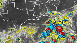
This image, taken at 9:15 p.m. Wednesday, shows storms in the Gulf of Mexico that forecasters say could become a tropical depression.
Elsewhere, forecasters on Wednesday saw the potential for a new tropical storm that could hit the U.S. Gulf Coast over the weekend.
A cluster of storms over the southeastern Gulf of Mexico on Wednesday could become a tropical depression by Thursday, with the help of upper-level winds that are forecast to aid development, the National Hurricane Center said in its 8 p.m. Wednesday tropical weather outlook.
“Most computer models are developing this into at least a tropical storm, if not a hurricane within the next two days,” CNN Meteorologist Jacqui Jeras said Wednesday evening.
“There is a ton of potential for flooding,” Jeras said. “One computer model solution here (puts) as much as 6 to 12 inches of rain on the Gulf Coast by Saturday morning.”
Other models have the system going into Texas, parts of which are dealing with drought and wildfires.
The system has a 60 percent chance of becoming a tropical cyclone in the next 48 hours, the hurricane center’s 8 p.m. outlook said.
As for Katia, it strengthened from a tropical storm to a Category 1 hurricane Wednesday night, with maximum sustained winds at 75 mph shortly before 11 p.m., the hurricane center said. The wind-speed threshold for hurricanes is 74 mph.
Shortly before 11 p.m., Katia was about 1,165 miles east of the Caribbean Sea’s Leeward Islands, moving west-northwest near 20 mph.
The storm could be a major hurricane with winds above 110 mph by Saturday night, possibly still hundreds of miles east of Puerto Rico, according to the hurricane center. It still is too early to predict whether Katia will pose any threat to land.
[Initial post, 8:06 a.m. ET] Tropical Storm Katia was gradually gaining strength over the Atlantic Ocean early Wednesday and could reach hurricane strength by the afternoon, the National Hurricane Center's 5 a.m. advisory said.
At 5 a.m., Katia was almost a 1,000 miles west of the Cape Verde Islands, moving west-northwest at 21 mph.
The storm's maximum sustained winds were 65 mph. Katia will become a Category 1 hurricane when the winds hit 74 mph.
The storm was forecast to become a major hurricane with winds above 110 mph by early Sunday.
It is still too early to predict whether Katia will pose any threat to land.
Katia is the storm name that replaced Katrina in the revolving list of names, according to the center. The list of Atlantic hurricane names is repeated every six years, and this year the list that was used in 2005 is being reused.
A storm name is retired if it is used for a hurricane that caused major damage, as Katrina did to the U.S. Gulf Coast in 2005.
"The only time that there is a change is if a storm is so deadly or costly that the future use of its name on a different storm would be inappropriate for obvious reasons of sensitivity," the hurricane center said
No comments:
Post a Comment